Trust in the Leader of Collaborative Process Design and Facilitation
TOOL T-13 | Register | Module 3: Coordination & Alignment
Non-Landowner Impact Register
WHEN TO USE During land acquisition and site preparation; before any clearing, construction, or access restriction activities.
How to Use It
1. For each land parcel or project impact area, systematically identify non-title-holders with livelihoods or access interests: tenant farmers, agricultural laborers, fisherfolk, water users, seasonal workers, informal settlers.
2. For each identified individual or group, document: name or group description, type of livelihood interest, nature of impact, contact information, and any existing informal arrangements with the landowner.
3. Notify all registered non-landowners of activities that will affect their livelihoods, using accessible channels.
4. Include non-landowners in engagement sessions relevant to their interests.
5. Create a clear pathway for non-landowners to raise grievances, and ensure they know about it.
6. Review and update at each phase as land use and affected populations may change.
Purpose
To document tenants, farm workers, fisherfolk, and other groups who do not hold formal title but whose livelihoods or access will be affected by the project, ensuring they are included in engagement, compensation planning, and grievance processes. Title-only processes miss the majority of those actually affected.
Field Rationale
The formal land acquisition process engaged landowners and title-holders. Tenants and farm workers, who were actually cultivating the land, were not part of the formal process. Their livelihoods were directly disrupted by clearing, but they had no formal channel for raising concerns and no record in project documentation.
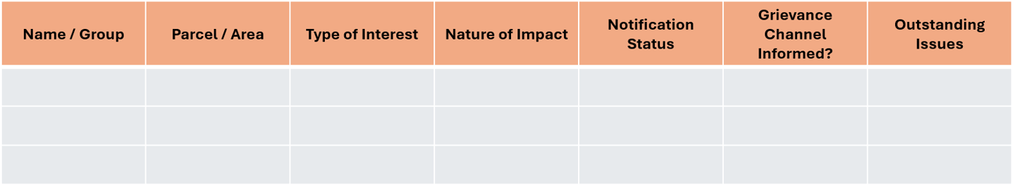
Fillable Template: Non-Landowner Impact Register
Guidance Notes
! Field Note — In the Philippines, a significant proportion of agricultural land is farmed by tenants and seasonal workers with no formal documentation of their arrangement. Do not rely on landowner reports to identify tenants, ask directly in communities. Walk the land, talk to workers.
Adaptation Guidance
For fishing communities, the 'land' boundary extends to water, identify fisherfolk whose fishing grounds, access routes, or anchorage areas overlap with the project footprint. This is particularly important for floating solar and offshore wind projects.
This website shared to the public for free courtesy of the
THE CONFLICT RESOLUTION GROUP FOUNDATION, INC.
www.coregroup.org.ph * info@coregroup.org.ph
through our SustainABILITIES Lab Project
All rights reserved. The Conflict Resolution Group Foundation 2026.
© Pixelhaze 2024. A Hostinger Website Builder Template by Pixelhaze Studio