Trust in the Leader of Collaborative Process Design and Facilitation
TOOL T-01 | Mapping & Analysis | Module 1: Pre-Engagement Diagnostics
Stakeholder Mapping Tool
WHEN TO USE Before the first community engagement activity at any project stage.
How to Use It
1. List all geographic areas within the project's potential influence area, not just the immediate footprint.
2. For each area, identify all stakeholder groups: landowners, tenants, fisherfolk, women, youth, elderly, business operators, informal settlers, and any others with livelihood or access interests.List all geographic areas within the project's potential influence area, not just the immediate footprint.
3. Identify institutional actors: LGUs, national agencies, CSOs, churches, cooperatives, and any others with authority or trust in the area.
4. For each group assess: (a) level of direct impact (H/M/L), (b) level of influence over project outcomes, (c) likely attitude toward the project, and (d) preferred engagement channel.
5. Map relationships between groups: alliances, conflicts, hierarchies, and groups likely to speak for others.
6. Identify which groups are most at risk of exclusion (those with less power, less access to formal channels, or lower literacy).
7. Review and update the map at each project stage transition.
8. Share the map summary with the engagement planning team before any consultation design.
Purpose
To systematically identify all parties who may be affected by or have influence over the project (their roles, relationships, levels of influence, and likely attitudes). A stakeholder map is the foundation of any engagement plan. Without it, key groups are missed, engagement sequences are wrong, and the project enters communities unprepared.
Field Rationale
Initial stakeholder mapping was limited to formal titleholders and LGU officials. Fisherfolk, tenants and farm workers, and women's groups were absent from early engagement records. Their exclusion from the map meant exclusion from early engagement, and their concerns surfaced later as disputes rather than early inputs.
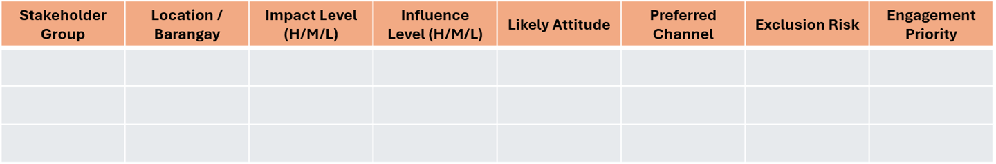
Fillable Template: Stakeholder Mapping Table
Guidance Notes
! Field Note — The most common mapping failure is limiting the stakeholder list to those who are easy to reach. Fisherfolk, tenants, women's groups, and informal settlers are routinely absent from initial maps, but are often the groups most affected. Build the map from community walks and local knowledge, not just official records
Adaptation Guidance
In areas with complex land tenure, ask specifically about non-title-holders: Who farms this land? Who has access rights not recorded in titles? Who relies on this area for water, passage, or grazing?
This website shared to the public for free courtesy of the
THE CONFLICT RESOLUTION GROUP FOUNDATION, INC.
www.coregroup.org.ph * info@coregroup.org.ph
through our SustainABILITIES Lab Project
All rights reserved. The Conflict Resolution Group Foundation 2026.
© Pixelhaze 2024. A Hostinger Website Builder Template by Pixelhaze Studio